


Businesses are increasingly using location data to their advantage. While satellites are getting more advanced, more geographical software is being developed and a massive amount of location data on consumers is available for companies in every industry. But what is the importance of location data and how can you use this data for your company.
The Importance of Location Data
In this digital era, geolocation tops the sophisticated business tool list. Though the typical meaning of geolocation means the usage of modern technology device location target, it is widely used in different applications to locate human customers. With advancement in data sciences, geolocation is gaining prominence.
The amount of information about consumers is increasing significantly over the years and applying target marketing is already done with this information. But when also applying this gathered data on the locations your customers or consumers are it becomes powerful. Data is used for spotting customer location, worldwide. Even finding out the connection between distinct data to attract new customers and preserve the old ones have become possible.
Big Data Models in Geolocation
Many models are being used to determine accurate location data and According to IT experts at Aussie Writings, a synergy of geolocation and big data is reshaping our everyday routines. They noted that these two systems changed the way we design digital marketing strategies, traditional retail stores, recruiting, and many other areas of business. Read more on the 6 Models that are being used in the blog from Olivia Ryan from Techbullion.
Cartographers are making a comeback
 The demand for cartographers is projected to grow nearly 30 percent by 2024. Big companies like Grab, Uber Foodpanda and others are built up from using Geospatial locations. This shift also noticed at universities where between 2007 and 2015 the amount of people graduating with a master’s degree in cartography increased more than 40% on average per year. Around the world the need for Cartographers is rising. CARTOGRAPHY IS THE new code, a recent post by Tim Enthoven explains this in depth.
How to use Location data for your business
Using Location data helps you to gain business insights. By bundling location data with geospatial analysis software it allows you to get valuable information, and to find new ways to reach customers by predicting their behavior.
In order to gather location data it all starts with geocoding, this is the process of transforming a description of a location - such as a coordinates, an address, or a name of a place - to a location on the earth’s surface. It’s a service that is offered by Google Maps for instance. But software programs go further, they gather geocoded data points with additional property and consumer information in order to provide a more detailed picture of the person or place being examined. This process is used for mapping or spatial analysis.
Another part is the concept of the spatial interaction model. This is specifically used to map and model the interactivity between various factors in distinct locations. A method that is extremely useful when it comes to understanding any data you might have with more than one location component. Organisations can analyse these geo-enriched data sets to target and obtain customers and increase sales.
CARTO, a company specialised in Geolocation, is a location intelligence software which gives to businesses the opportunity to build their own spatial interaction models for gathering geo-enriched data and turning it into business outcomes.
For example, the team at Carto built a model for a retail company in Madrid. This model shows the probability of a customer deciding to shop at a specific location based on existing alternatives. This helps developers predict the attractiveness of a new mall based on its location in Madrid.
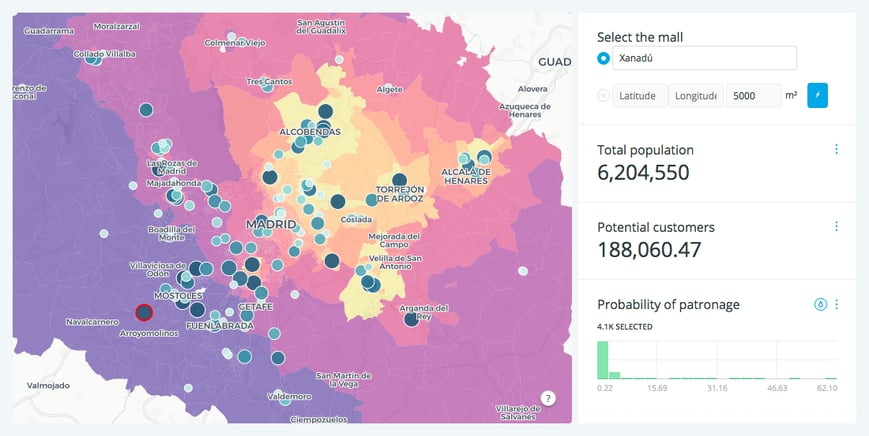
The map above takes the location of each mall in madrid. By using factors such as size, distance and the location of alternatives (competing malls), it creates a probability surface. This expresses the likelihood of households in a particular region to shop at a specific mall, with the more purple regions having more likely customers.
In this example, we can see the position of Xanadu, and the total number of potential customers based on its location and distance to their competitors. Thanks to this model, it’s possible to create a virtual mall like Xanadu and evaluate the potential market.
A spatial interaction model like this can also be useful for other branches like a real estate development, by gaining substantial insight into the attractiveness of a particular new location. Moreover, a retailer could use a similar spatial interaction model to understand whether a new location would cannibalise business from existing locations or where to place a new store to best engage their competition.
Innovators in all sectors, not only in retail and real estate, could use this model as it helps to draw insights and shapes their decision making based on location data. With as a result, location intelligence can provide businesses with a competitive advantage.
Learn more about using location data to your advantage in our Hands on Workshop. We take a business case from your company and see how geospatial solutions can help you improve your business.

 Twitter
 Youtube